how to get to sorrow's end?
Moderators: chossmonkey, Dom, granite_grrl, peter, Climb Nova Scotia, Matt Peck
8 posts
• Page 1 of 1
how to get to sorrow's end?
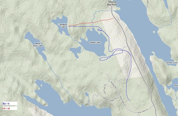
So what's the best way to get in and out of that place? We were there on the weekend and it was a gong show on the approach. On the way out we did a straight shot to the road but had to cut across someone's property. What the scoop?

- HDW
- Posts: 21
- Joined: Mon Oct 25, 2010 8:12 am
Re: how to get to sorrow's end?
The way you took on the way out certainly seems the shortest way, but it's not necessary to cut across that property... There is access to the road about 3 properties up (that is back towards the 333, from the old fish plant parking lot) that goes down a path on a steep hill through what may be crown land, or at least undeveloped land. But coming back it's hard to resist when it opens up so clearly and it's not obvious you're on private land until you're standing in the back yard.
There is a more direct route used in the past from where your approach started as well, but I'm not sure what the current status of the use of Nice View Drive is.
There is a more direct route used in the past from where your approach started as well, but I'm not sure what the current status of the use of Nice View Drive is.
-

patzer - Posts: 140
- Joined: Sat Jul 02, 2005 1:53 pm
Re: how to get to sorrow's end?
What route are people using to get there these days?
Is the following route still being used:
http://novascotiaclimb.tripod.com/crag_info.html#Sorrows_End
Does anybody have a gps track for this one?
-Sean
Is the following route still being used:
http://novascotiaclimb.tripod.com/crag_info.html#Sorrows_End
Does anybody have a gps track for this one?
-Sean
-

chameleon - Posts: 444
- Joined: Mon Jan 24, 2005 4:41 pm
- Location: Halifax
Re: how to get to sorrow's end?
This trail on Teths website is the shortest, Driest rout that dosen't go over any known Private land. Teth flagged some of it in early 2003 late 2002 ( not sure ). Keith, Dave C, Craig P and I finished it, cut back what teth started, and added more flag's after juan in Oct 2003. From what I can remember the trail from nice view is wet almost all year.
-

Zamboni - Posts: 935
- Joined: Fri Oct 29, 2004 8:59 pm
- Location: Halifax
Re: how to get to sorrow's end?
thanks conan.
i just checked the property records and you're right - the trail that 'theteth' and you guys flagged is entirely on provincially-owned land, which is kind of cool (from a long term access perspective).
the problem is that it's longish, hard to follow, and I have the impression that people just aren't going in that way anymore. maybe i'm wrong.
teth's map looks kind of sketchy, but maybe it's accurate?!
i found a gpx track on tracstarr's site: http://www.tracstarr.com/gpstracks
but i couldn't work with the file (can anybody else get this to work?)
if the trail is cleared better and we have good maps, maybe it'd be used more. but if people can get in elsewhere without problems - maybe we just leave things as they are. any cns access reps on this case?
thoughts?
S
-

chameleon - Posts: 444
- Joined: Mon Jan 24, 2005 4:41 pm
- Location: Halifax
Re: how to get to sorrow's end?
The trail from Nice View has wet spots, but it's pretty easy to stay dry the whole way. There are so many forks that re-merge you can almost always pick a dry one, or do a little hopping over some rocks. It also seems a fair bit quicker, although looking a map it seems it should be the other way?!
I'm surprised all those ATV trails are on private land though - who wants to own that? They are used frequently by.. ATVs as well, and other non-climbing hikers. Was the other approach just found as a prophylactic measure, or were there ever complaints/requests not to use the other one?
I'm surprised all those ATV trails are on private land though - who wants to own that? They are used frequently by.. ATVs as well, and other non-climbing hikers. Was the other approach just found as a prophylactic measure, or were there ever complaints/requests not to use the other one?
-

patzer - Posts: 140
- Joined: Sat Jul 02, 2005 1:53 pm
Re: how to get to sorrow's end?
historically:
1.Nice View Drive was the original/preferred access.
2. there were complaints from landowners on that road (Zig heard most of it, I recall) so we found a new way in...which was a pretty direct line through someone's quarry (with permission)...they developed the lot and then denied us access....just before the guidebook was published
3. consequently i found that chaotic approach that was included in the guide
4. that trail was too confusing (but probably led to the discovery of the TBay Woods boulders (no longer accessible either)), so Teth and co found the trail further north that is on crown land.
current status: nice view again the preferred approach? crown land route as a backup?
-

chameleon - Posts: 444
- Joined: Mon Jan 24, 2005 4:41 pm
- Location: Halifax
Re: how to get to sorrow's end?
I remember taking the Crown Land trail when it was freshly cut and we found our way to the cliff relatively easily without help from locals. It seemed like a great solution to the land access issues. I was thinking to myself at the time though, that if the trail got faint it would be difficult to find your way. Actually, I find it's hard to find your way in any of that NS tundra like LOC.
I want to go to hell... there's probably lots of rock to climb there.
-

Fred - Site Admin
- Posts: 3140
- Joined: Wed Oct 20, 2004 12:30 am
- Location: Fredericton, NB
8 posts
• Page 1 of 1
Who is online
Users browsing this forum: No registered users and 4 guests